As summer unfolded in the Northern Hemisphere, Australians observed with growing concern the series of severe weather events that dominated headlines. From the raging fires in Hawaii and Canada to the sweltering heatwaves sweeping across the US and Europe and the alarming oceanic temperature spikes, the intensity and frequency of these phenomena have been nothing short of alarming.
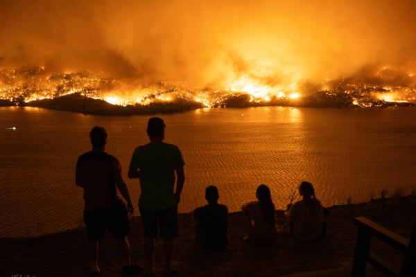 Large wildfires devastated Kelowna in British Columbia in August 2023. (Credit: Kyle Brittain)
Such events have left many Australians anxious, contemplating the implications for our imminent summer season. Adding to the anticipation, the Bureau of Meteorology has recently unveiled their long-term forecast for the upcoming months, shedding light on what we might expect.
The forecast is released each year by the BoM, highlighting the trends we should expect to see during the peak months for severe weather events from October to April. This is traditionally when we see the peak activity for events such as hail, severe thunderstorms, flooding, tropical cyclones, heatwaves and bushfires.
Across the globe, average sea surface temperatures (SSTs) have been consistently high during 2023. Since April, temperatures have remained at record levels, with August breaking both the highest monthly average and the highest daily global average records. SSTs have a profound influence on Australia's weather patterns. El Niño and La Niña are driven by Pacific SSTs, respectively bring drier and wetter conditions to the continent. Similarly, the Indian Ocean Dipole, dictated by SSTs in the Indian Ocean, can sway our rainfall patterns. Elevated SSTs can also trigger marine heatwaves, impacting marine ecosystems like the Great Barrier Reef and influencing atmospheric conditions.
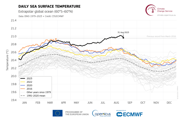
Daily sea surface temperature (°C) averaged over the Extrapolar global ocean (60°S-60°N) during 2023
(Data source: ERA5. Credit: Copernicus Climate Change Service/ECMWF.)
The BoM declared an El Niño event during September, along with a Positive Indian Ocean Dipole (IOD). Both these climate drivers bring warm air and dry temperatures to Australia, and are in addition to other recent conditions such as low soil moisture, above average temperatures and below average rainfall. This has helped form a long-range forecast for Australia which is far from the previous years of wet and cooler than average summers.
What can we expect to see?
The already drying landscapes and warm temperatures mean that there is an increased risk of heatwaves across all of Australia for Spring and Summer. Prolonged periods of extreme heat can lead to a range of health issues, from dehydration and heat exhaustion to more severe conditions like heatstroke. Vulnerable populations, such as the elderly, children, and those with pre-existing health conditions, are particularly at risk. Beyond health concerns, heatwaves can strain our energy systems with heightened electricity demand, potentially leading to blackouts.
.png?width=500&height=275&name=image%20(3).png)
Unusually warm temperatures over Spring & Summer bring an increased threat of heatwaves.
(Credit: BoM)
Many areas in the Northern Hemisphere saw unprecedented Marine Heatwaves during their summer, and unfortunately there is the possibility of similar events in Australian waters. Such events can lead to widespread coral bleaching, especially in areas like the Great Barrier Reef, and drive many marine species to seek cooler waters, disrupting local ecosystems. Seagrass meadows, vital for numerous marine creatures, face decline, while certain species may experience mass mortality events. Additionally, warmer waters can exacerbate ocean acidification and reduce dissolved oxygen levels, creating challenging environments for marine life.
Increased bushfire risk during Spring has been forecast for areas across the Northern Territory, Queensland, New South Wales, Victoria and South Australia. It is important to note however, that these risk areas and levels may increase for Summer as weather conditions further strengthen fire conditions.
.png?width=600&height=414&name=image%20(4).png)
Spring bushfire outlook showing areas of increased fire risk across Australia (Credit: AFAC)
Agencies are reminding residents across Australia to prepare their properties for fire as soon as possible, as many regions have also seen increased fuel growth thanks to recent rainfall, which exacerbates the fire risk. The fire season has already begun for many parts of the country, including the Northern Territory, NSW and Victoria, with fires along the South Coast of NSW last week destroying three homes and thousands of acres in areas that had already seen large fires in 2020.
Through data in Climatics, we identified several locations which are potentially at even greater potential danger of fire throughout the season, due to the forecasted risk and lack of fires in the areas for at least 20 years. These are:
Melbourne – A concern exists around the Dandenong Ranges where widespread bushfires have not occurred since 1997.
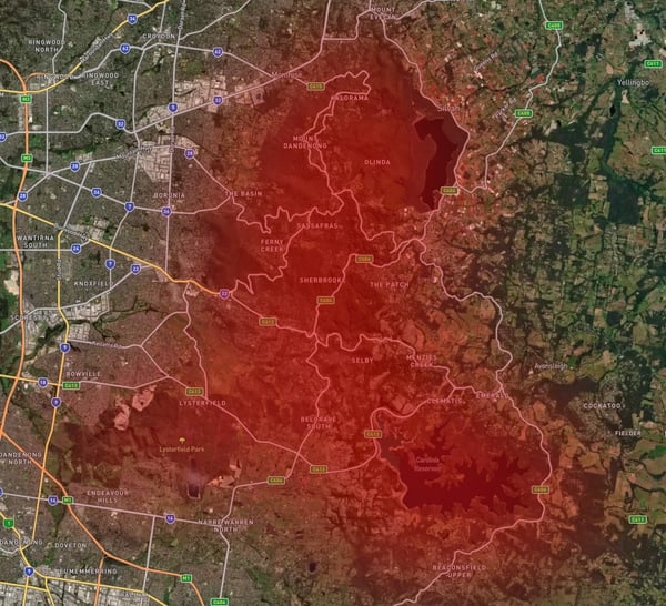 Dandenong Ranges has an increased fire risk this season (Credit: EWN)
Sydney – A concern exists around northern and north west areas of Sydney which haven’t seen significant widespread bushfires in nearly 30 years
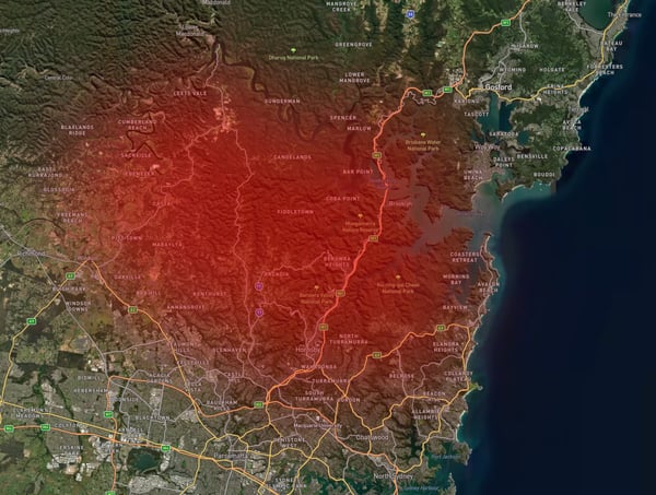 Northern and north west areas of Sydney haven't seen significant fires in nearly 30 years (Credit: EWN)
Brisbane – A concern exists around the north-west, south-west and islands area of Brisbane where significant widespread bushfires have not occurred for some time. Morton and Stradbroke islands off the coast have seen some bushfires in recent history however parts of the islands remained unaffected. Gold Coast Hinterland is also a concern.
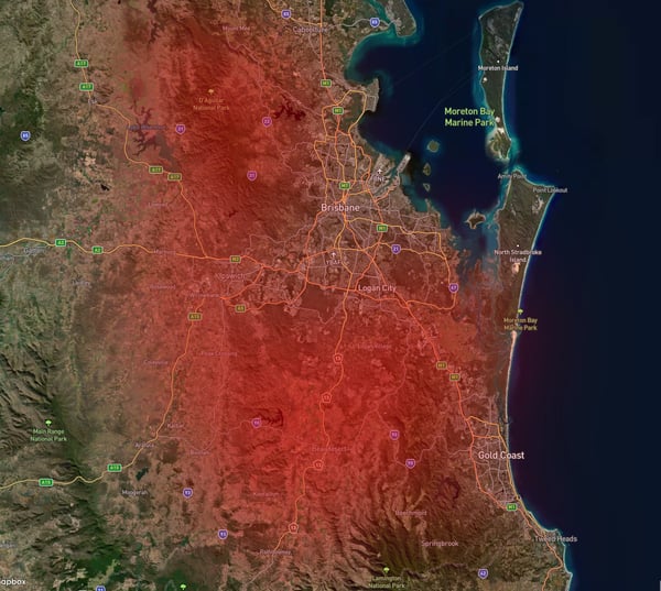
North-west, south-west and islands area of Brisbane which have a higher risk of fires (Credit: EWN)
It is especially important for residents in these areas to be familiar with their bushfire plan and prepare their properties accordingly.
What about other severe weather?
The good news from the BoM is that we should see a decrease in other severe weather events such as tropical cyclones, floods and severe thunderstorms.
While there is a forecasted 80% decrease in tropical cyclones this season, it's crucial to note that Australia has never experienced a year without a tropical cyclone since records began. Residents should remain vigilant and prepare for the cyclone season as usual. As for severe thunderstorms, despite an early start to the season, Spring and Summer—Australia's peak storm months—are expected to see typical activity, with no anticipated increase in storm numbers. Lastly, even with a low overall risk of flooding, recent flash floods in areas like Gippsland and Lismore serve as stark reminders of the unpredictability of weather events. It's essential to remember that localised flooding remains a potential threat during the wet season, underscoring the need for continued caution and preparedness.
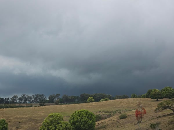
Storms approaching outer Lismore before flash flooding on September 26, 2023 (Credit: EWN)
In light of the recent seasonal outlook, it's essential to remember that any weather patterns and forecasts may change. Staying updated with the latest outlooks is crucial for safety and preparedness. The most effective way to stay ahead of severe weather events is by leveraging the Early Warning Network with our suite of alerting products which ensures that you're informed in real-time, allowing you to take necessary precautions.