Victoria Braces for Unseasonal Severe Thunderstorms with Potential for Destructive Winds and Large Hail
Despite being late Winter, conditions are forecast to be more spring-like as severe thunderstorms...
Residents of Western Australia's southwest are being urged to prepare for severe weather as a strong cold front approaches the region. The Bureau of Meteorology has issued a series of warnings highlighting the potential for heavy rain, flash flooding, and damaging winds. The front is set to impact areas from Perth to Mandurah, Bunbury, Busselton, and Manjimup and extend north to Yanchep, Lancelin, and Jurien Bay.
Thunderstorms will begin this afternoon ahead of the front, and intensify this evening as the it moves across the region. Heavy rainfall will likely start in the South West this evening, spreading north to Perth and the Central West by overnight. Rainfall totals could reach 30 to 50 mm in the far south-west, with isolated totals up to 70 mm. The Perth area could see more modest totals between 20 to 30 mm, possibly reaching 40 mm in the hills. Strong winds averaging 50km/h to 60km/h with gusts up to 100km/h are also anticipated.
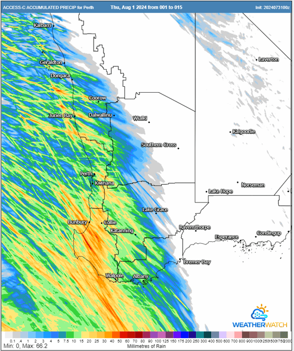
High resolution ACCESS Accumulated Rainfall totals next 36 hours. Image via WeatherWatch MetCentre.
Meteorologist Ben McBurney from EWN said, "Whilst typical for this time of the year, this is one of the strongest cold fronts we've seen in several weeks." Sheep Grazier warnings have been issued for the Lower West and South West regions, as the adverse weather conditions could pose a risk to livestock.
The forecasted wind gusts have the potential to bring down trees and power lines, posing significant hazards. Flash flooding from the heavy rain could also lead to dangerous driving conditions and property damage. A few localised storms may also contain hail up to 2-3cm, mainly from Perth and south. Strong wind shear also brings the risk of brief coastal tornadoes, which aren't uncommon with these kinds of winter cold fronts in southwest WA.
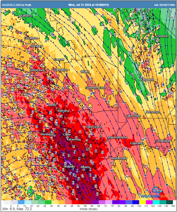
Strong winds just above the surface (850mb) will likely translate to damaging winds for some regions, particularly with shower and storm activity. Image via WeatherWatch MetCentre.
As areas battle the cold front, parts of the Pilbara, Kimberley, WA’s interior, and inland South Australia are expected to experience prolonged wet weather due to an upper-level trough. Rainfall in these areas could range from 15 to 30 mm over the next five days, with isolated spots receiving up to 60 mm. The heaviest rain is likely on Thursday into Friday and again on Friday night into Saturday, with potential falls of 10 to 15 mm in three-hour periods.
As the weather front moves towards the South Australian border, it will gradually weaken but continue to bring rain and storms. It’s crucial for all residents in the path of this severe weather to remain vigilant, prepared, and responsive to evolving conditions. Stay tuned to the Bureau of Meteorology for the latest warnings and updates.
Despite being late Winter, conditions are forecast to be more spring-like as severe thunderstorms...
As summer comes to an end, we reflect on the major weather events that shaped Australia over the...
A dangerous mix of severe weather will strike western and southern parts of Western Australia...