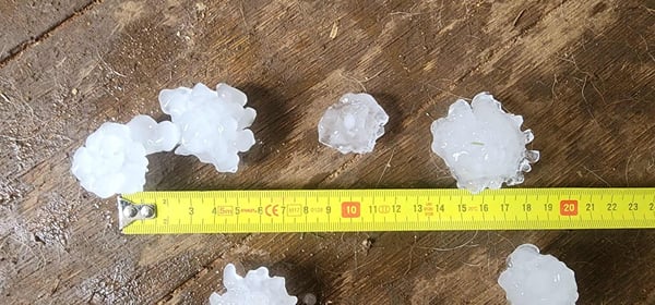
On Sunday, Victoria experienced a severe weather event that was highly unusual for the final week of winter. A powerful thunderstorm system swept across the state, unleashing destructive winds, torrential rain, and enormous hailstones that left a trail of damage in its wake. The storm left thousands without power, damaged buildings, and downed countless trees, particularly in central Victoria.
 Hailstones in Bendigo - 25 Aug 2024. (Image courtesy of Kylie Ermel)
Bendigo was one of the hardest-hit areas, with hailstones the size of golf balls and, in some cases, as large as tennis balls reported in the city and surrounding areas like Huntly and Yarck. This storm, which tracked from south of Charlton to south of Strathbogie, was marked by incredibly fast-moving cells and a setup more characteristic of spring or early summer than late winter.
 Hailstones in Bendigo (image courtesy of Emily Rose)

Hailstones located at Bridgewater on Loddon (image courtesy of Glen Corrigan)
Wind gusts reached 150 km/h at Mt Buller around 6 pm, while Melbourne Airport recorded gusts of 109 km/h shortly after. The SES received reports of hail up to 5 centimeters in size, with over 400 call-outs between 6 pm and 9 pm as thunderstorms intensified over Melbourne. These storms, combined with unusually high temperatures for this time of year — 6 to 10 degrees above average — created a volatile and destructive weather event.
The unusual weather pattern, driven by very strong wind shear, made for a dangerous and fast-moving storm system. Not only were there widespread reports of hail and damaging winds, but there were also sightings of a funnel cloud near Bendigo, and possible tornado damage in areas like Whorouly and Gapsted. In Kyabram, trees were torn from the ground and thrown onto houses, further highlighting the storm’s destructive power.
 Wind damage at Macs Cove, Victoria. Image courtesy of Bradley Kirley
-2.png?width=600&height=613&name=image%20(16)-2.png) Hail tracks across Victoria on Sunday (image via HailTracker, powered by Weatherwatch)
Hail tracks across Victoria on Sunday (image via HailTracker, powered by Weatherwatch)
As the storm developed, EWN's operations team was monitoring and responding to the fast-moving event. Our technology and verification process played a crucial role in tracking the storm and alerting those in its path. The HailTracker system powered by Weatherwatch identified 14 distinct hail tracks, and we issued 261 hail alerts during the day - a record for a single day - ensuring that our clients had the most up-to-date information to protect their assets.
EWN’s rapid response was particularly vital for industries such as insurance and commercial solar farms, which were significantly impacted by the storm. For the insurance industry, accurate and timely hail alerts allowed insurers to proactively manage claims, assess damage, and deploy resources where they were most needed. By providing real-time data on hail size and storm tracks, EWN enabled insurers to offer immediate assistance to their policyholders, mitigating further damage and expediting the claims process.
Commercial solar farms, which are especially vulnerable to hail damage, also benefited from EWN’s precise tracking and alerting systems. The ability to receive early warnings of approaching hailstorms allowed these farms to take protective measures, such as adjusting panel angles or initiating shutdown procedures, to minimise damage. By leveraging EWN’s technology, solar farms across Victoria were able to safeguard their infrastructure, ensuring that energy production could resume quickly once the storm had passed.

Red: BoM Severe Thunderstorm Warning: damaging winds, large hail, heavy rain. Green: EWN Hail Alerts
(via HailTracker, powered by Weatherwatch)
Why This Storm Was So Unusual
This storm was exceptional not only because of the damage it caused but also because of its timing and intensity. Winter storms in Victoria rarely exhibit the characteristics seen on Sunday—particularly the combination of large hail, destructive winds, and unusually warm temperatures. The presence of strong wind shear, typically associated with spring or early summer storms, was a standout feature of this weather system, making it a rare occurrence for this time of year.
Sunday’s storm was a powerful example of how quickly severe weather can develop and the critical role that early warnings play in minimising damage. EWN's timely alerts and advanced tracking systems were instrumental in helping industries like insurance and commercial solar farms respond swiftly and effectively to the storm, protecting their assets and maintaining operational continuity. As climate patterns continue to shift, the ability to accurately track and respond to severe weather events will become increasingly crucial.
At Early Warning Network, we remain committed to leveraging our technology to protect lives and property, and our technology ensures that our clients are always one step ahead of whatever weather systems may bring, ready to take action when it matters most. If your business or organisation could benefit from our advanced alerting services and real-time weather intelligence, we invite you to contact us today.
Reach out to our team to learn more about how we can support your needs.