Western Queensland Flooding is a Disaster of Unprecedented Scale
The heart of outback Queensland is experiencing a once-in-a-generation flood disaster that is unfolding across a region more than twice the size of Victoria, leaving catastrophic damage in its wake. With over 140,000 head of livestock lost or missing, thousands of kilometers of fencing and private roads destroyed, and entire towns inundated, this is being called the worst flooding event in over 50 years - and the situation continues to evolve.
The devastation began after a period of record-breaking rainfall drenched western and central Queensland. Saturated catchments and overwhelmed river systems were pushed to breaking point by the remnants of ex-Tropical Cyclone Dianne, which swept across the state in late March. This system, though fast-moving, brought yet another wave of intense rainfall, in some areas up to 100mm, falling on already waterlogged ground.
With the ground unable to absorb any more moisture, nearly all rainfall has flowed directly into river systems, causing widespread riverine flooding. Towns like Thargomindah, Eulo, and Adavale have been among the hardest hit, with levees breached and critical infrastructure compromised.
More than two Victorias.
— David Crisafulli (@DavidCrisafulli) March 31, 2025
That's the area impacted by the disaster in Western Queensland right now.
Our focus is continuing to supply towns and farmers with fodder, fuel and food.
These Queenslanders live in a remote area of our State but they have our full support for… pic.twitter.com/3My2hiQWkk
Initial assessments from the Queensland Department of Primary Industries estimate more than 140,000 livestock, such as cattle, sheep, goats, and horses, have perished or are missing. This number is expected to rise as waters slowly recede and the true extent of damage is revealed.
Farmers have described heartbreaking scenes from the air: cattle stranded on tiny islands or wading chest-deep in floodwaters, with many unlikely to survive. Entire properties are underwater. Helicopters have been deployed for supply drops, livestock rescues, and evacuations, though in many areas, access remains severely limited.
Communities are showing incredible resilience. In Thargomindah, where floodwaters reached 7.5 metres and overtopped the town’s levee system, residents spent nights at the airport, doubling as a makeshift hospital and shelter. In Eulo, broken levees have left homes and farms inundated, while graziers have been forced to swim cattle to higher ground.
Personal stories are emerging that speak to both the scale of loss and the spirit of the outback. Families are displaced, sleeping in cars, waiting out the flood in nearby towns. Others have lost everything — homes, equipment, herds — but are grateful to be safe.
.jpg?width=700&height=507&name=image%20(4).jpg) Flood watches and warnings in place from March 6 - April 1 2025
Flood watches and warnings in place from March 6 - April 1 2025
The flooding remains widespread across western and central Queensland. While some areas are seeing water levels begin to recede, others are still bracing for more rainfall. Rivers remain swollen, and the flood threat persists.
The Bureau of Meteorology has maintained multiple flood warnings across the region. The remnants of ex-Tropical Cyclone Dianne have now largely passed, bringing some relief, but the aftermath continues to pose significant challenges.
Entire towns, including Thargomindah and Adavale, remain cut off. Damaged levees, washed-out roads, and destroyed infrastructure mean that recovery efforts are logistically complex and will take months, if not longer.
Emergency services, including SES and local councils, have been working around the clock. Government assistance has begun to flow, including fodder drops, fuel support, and financial relief for affected families. However, many in the region are calling for increased military support and a faster rollout of supplies.

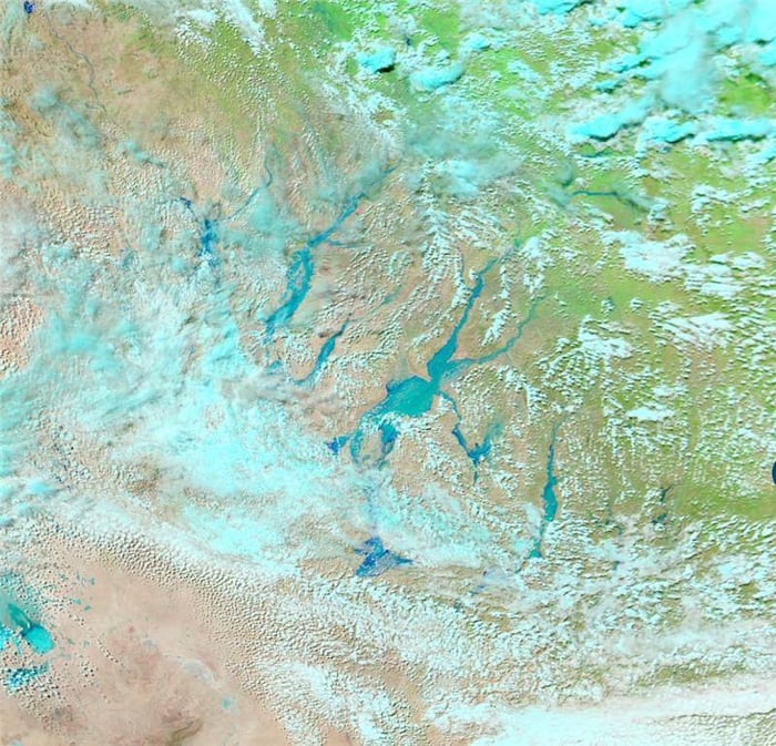
 Images via NASA Worldview show rivers across Queensland in full flood
The EWN team has been working closely with clients across high-risk sectors to provide real-time, actionable flood intelligence. Our flood monitoring and rainfall alerting systems have played a critical role in helping organisations track the rapidly changing situation, make informed decisions, and protect their people and assets.
-
Our river gauge monitoring and flood forecast tools are actively monitoring water levels across Queensland, identifying risk areas before they escalate.
-
Clients have received automated alerts and updates tailored to their operational locations, enabling preemptive action, from supply chain adjustments to activating local response plans.
-
EWN's GIS platform has provided dynamic, visual mapping of rainfall intensity, river height observations, and flood risk overlays, helping decision-makers respond more precisely.
The immediate outlook includes scattered showers and potential thunderstorms through the week, though a dry air mass is expected to bring some reprieve by the weekend. Even so, the flooding event is far from over — recovery will be measured in months, not weeks.
In the longer term, the economic and agricultural impacts are expected to ripple across the country. A shortage of livestock will likely lead to increased meat prices in urban centres. Damaged freight routes, like the Gregory Developmental Road, are hampering the movement of goods across inland Queensland, highlighting the fragility of regional supply chains during extreme weather.
As the waters slowly retreat, the full extent of the disaster is becoming clear: millions of dollars in lost infrastructure, devastated farmland, displaced communities, and a massive toll on the mental and emotional well-being of residents.